Feeds:
Posts
Comments

Archive for May, 2010

Another solo paddle down and up the the Hackensack River from Laurel Hill Park to Route 1-9 Truck Route past the Pulaski Skyway and back.  The weather was slightly overcast with a slight breeze but the temperature was in the low 70’s so I was very comfortable the entire paddle.  In total the trip was 8.5 miles round-trip and it took just over 3 hours.  I did this trip solo working hard all the way down and up the river.

To view the uploaded pictures in my Picasa Web album, click the ink below:
http://picasaweb.google.com/lgindoff/20100522HackensackRiverSGreatHornAtTheMouthJerseyCity?feat=directlink

This was a very wide portion of the river at points and though I was paddling downstream initially, I think the tide was coming in and therefore I was paddling against the current as well as the wind.  While I was tired on the way home it was definitely easier.  There was a chop to the water and wakes from the 3 or 4 motors boats I past provided a nice roll to the river.  There was more movement in the water than I was used to and gave me a good work out as I paddled for almost 3 straight hours.

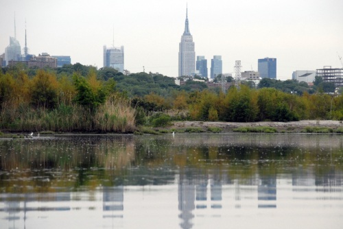
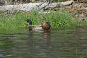
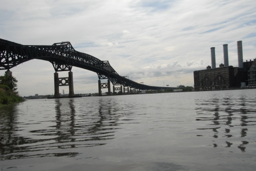
This trip was mainly about seeing the sights of industrialized New Jersey with the Empire State Building and the rest of the New York Skyline looking in the background.  While I was focusing on bridges and power plants I did encounter a few cormorants sunning on top of some pilings and got some good pictures of them.  I also caught a hawk circling above the Laurel Hill Rock with the faded Steal Your Face painted into it.  Finally, I took some pictures of a lovely ducky couple wading in the waters just past the Pulaski Skyway.  That was the extent of the wildlife as the rest of the trip was all about the New Jersey look, smell and feel that makes Tony Soprano proud.

Time Line:

  • 2:25 p.m. – Tweeted that I was about to Launch from Laurel Hill Park
  • 2:35p.m. –  First picture on the water
  • 2:41 p.m. – Cross the river to photograph 5 cormorants on pilings
  • 2:49 p.m. – Go under the eastern spur of the Turnpike
  • 2:57 p.m. – Go under NJ Transit railroad bridge
  • 3:32 p.m. – Turn the horn of the river by the huge coal fired power plant (2.5 miles)
  • 3:43 p.m. – Go under second NJ Transit railroad bridge
  • 3:53 p.m. – Go under Newark Turnpike (Road that connects 280 to Holland Tunnel and adjacent railroad bridge (3 miles)
  • 3:57 p.m. – Go under NJ Path railroad bridge
  • 4:11 p.m. – Go under Pulaski Skyway (3.5 miles)
  • 4:14 p.m. Photograph 2 ducks just past the Pulaski Skyway
  • 4:33 p.m. – Go under Route 1-9 Truck Route
  • 4:35 p.m. – Turn around and furthest southern extent  just past Route 1-9 Truck Route bridge (4.2 miles)
  • 4:45 p.m. – Go back under Pulaski Skyway (5 mies)
  • 4:57 p.m. – Go back under NJ Path railroad bridge
  • 4:59 p.m. – Go back under Newark Turnpike (Road that connects 280 to Holland Tunnel and adjacent railroad bridge
  • 5:04 p.m. – Go under second NJ Transit railroad bridge (6 miles)
  • 5:10 p.m. – Turn back on the horn of the river by the huge coal fired power plant (6.5 miles)
  • 5:30 p.m. – Go back under NJ Transit railroad bridge
  • 5:35 p.m. – Go back under the eastern spur of the Turnpike (7.9 miles)
  • 5:46 p.m. –  Last Picture on water (8.5 miles)
  • 6:06 p.m. – Pack and rolling out of the Laurel Hill Park.
Read Full Post »

It was a Monday I took off because it would be the last nice day before several with rain so I wanted to take advantage of the weather and head out kayaking.  My destination today was Secaucus, the Hackensack River and the mashes around the Meadowlands.  You never know what you would encounter in areas like this, the bodies of Jimmy Hoffa and or even the body of Adam Katz, so tragically killed while attending a Grateful Dead show in 1989s.

To view the photos from this trip in my Picasa Web album, click on the link below:

http://picasaweb.google.com/lgindoff/20100517KayakingTheMeadowlandsHackensackRiverfromSecaucus?feat=directlink

I would not encounter anything remotely nefarious on this day. Just lots of birds and a brand new park and access point into the Hackensack river called Millridge Point Park at the end of Millridge Rd in Secaucus, just past Secaucus High School and the new ball fields.  There is a new park built here with a really nice river walk and a boat launch.

From this site we had great access to the Hackensack River and the marshes the meander around the Meadowlands.  I would view the Sports complex and the formerly named Xanadu multi-colored white elephant.  I would meander in and around Route 3 and in, out and under both spurs of the New Jersey Turnpike.

Time Line

  • 11:05 a.m. – Tweet that I am about to launch
  • 11:10 a.m. – Take my first photo from the water.
  • 11:14 a.m. – Photograph a bunch of cormorants on poles in the river.
  • 11:29 a.m. – Done with bird pictures and now the lens is focused across the river at the Xanadu complex.
  • 11:44 a.m. – Paddling past the apartments just north of Rt. 3 and east of the river.
  • 11:46 a.m. – Paddling under the Rt.3 westbound bridge.
  • 11:51 a.m. – I Paddle under the Rt. 3 eastbound bridge.
  • 11:59 a.m. – At the base of the Crowne Plaza Hotel off of Meadowlands Parkway.
  • 12:03 p.m. – Reach my southern most extent on the Hackensack River to the day and head to the western bank of the river close the the western spur of the Turnpike.
  • 12:11 p.m. – Reach western bank of river.
  • 12:12 p.m. – Go under Exit 16W exit ramp and into channel off of the Hackensack River.
  • 12:14 p.m. – Go under western spur of Turnpike.
  • 12:18 p.m. – Turn around in channel as the furthest western point in the channel by the Exit 16W toll booth.
  • 12:26 p.m. – Back under western spur bridge.
  • 12:28 p.m. – Back under Exit 16W exit ramp and heading up the western bank of the river.
  • 12:39 pm. – Back under the Rt. 3 eastbound bridge.
  • 12:44 p.m. – Back under the Rt. 3 westbound bridge.
  • 12:59 p.m.  Paddle past abandoned marina.
  • 1:03 p.m. – Begin photographing cormorants just past the marina.
  • 1:08 p.m. – Witness back-hoe dredging a part of the river
  • 1:15 p.m. – Taking some of my best pictures of the Empire State Building
  • 1:37 p.m. – I’m back to the point on the river where I started.
  • 1:46 p.m. – Enter the channel off the river heading to go under the eastern spur of the Turnpike north of Rt. 3.
  • 1:52 p.m. – Heading under the eastern spur of the Turnpike.
  • 1:54 p.m. – Head toward 71st street, see a crane doing construction work and I turn around.
  • 1:56 p.m. – Go past the turnpike bridge.
  • 2:05 p.m. – Furthest southern extent up Cromakill Creek by the Liz Claiborne Building
  • 2:14 p.m. – Head back under the eastern spur Turnpike bridge.
  • 2:18 p.m. – Photographing white  birds  in the meandering channels on the other side of the Turnpike.
  • 2:26 p.m. – I get back into the Hackensack River.
  • 2:33 p.m. – I pass the boat launch and take some pictures of the original birds on the pilings I encountered at  the start of the trip.
  • 2:41 p.m. – Head back up the channel to go to the boat ramp at Millridge Rd.
  • 2:45 p.m. – Pass the boat ramp and begin to explore in the buggy, meandering channels.
  • 2:56 p.m. – Furthest extent into the meandering channels as I do a lap around a marshy island and head home.
  • 3:04 p.m. – Last picture in the water.
  • 3:22 p.m. – Car and boat are packed and ready to roll.
  • 4:24 p.m. – Car and boat unpacked and ready to blog and shower.

Read Full Post »